Deering Oaks
Guiding Principles and Objectives
Deering Oaks Reconstruction Project:
Peninsula Traffic Study; page "v-vi":
Guiding Principles and Objectives
Original text in black.
My comments are in blue : what I would call the "subtext" of the statement quoted. Remember, the Oaks Plan takes precedence over all of this study.
The "Guiding Principles" page v
Development should be mixed-use in nature, and should serve the needs
of the Peninsula’s residents.
Unless those needs (clean air, safety,
mobility) conflict with the Oaks Plan.
Change the City’s Ordinance so that level of service (LOS)
criteria are not necessarily the driving force behind roadway
improvements.
Usually illegal for a reason: things get bad
fast when the standards are not maintained. That's why they are
standards. Seeing that the Oaks supporters want to take State Streets
"B" rating to an "E" or "F", this is reprehensible.
When roadway changes are made, equal attention should be given to
infrastructure in support of
pedestrian safety and mobility.
Interesting
statement : Seeing that Oaks supporters want to
decrease safety and
mobility by making Park Avenue two lanes wider, while increasing
accidents and congestion, this is specious.
Another guideline for Oaks supporters to ignore.
Update March 2015: After this plan was killed by MDOT in 2008 because it didn't meet any requirements for installation, and after The Friends and Parkside failed to get Route 77 rerouted around the peninsula in 2013, they dusted off Plan-S2 and started up the band again. They DID take out the cut-through elimination. The "pedestrian safety and mobility" mentioned is seen as being threatened by the demon drivers: vehicles were speeding, causing accidents, and hitting pedestrians and bikers.
BUT, the accident information from the City and state shows they are still lying: 361 accidents in years 2011-2013; just one caused by speeding. There were 26 ped / bike accidents, 19 of which were the fault of the ped or biker. 4 had dual responsibility, with just 5 the fault of the driver. Bikers were smacking into cars, blowing through intersections; peds texting while walking, running into the road.
State has a Critical Rate Factor of .87, which means it's safer than most roads of its type elsewhere in the state; High St. a CRF of 1.07, which means it's slightly more dangerous.
It's funny project supporters don't mention any of this , isn't it? I wonder why?
Traffic planning should fully respect and encourage pedestrian, bicycle, transit and other modes of transportation. Sounds nice. As long as it's not a car that's involved.
Traffic flows should be routed where they will have the
least impact on sensitive areas such as neighborhoods and open spaces.
Read: "Don't send them through Parkside or
Deering Oaks". Also, considering that Plan supporters
expect
the traffic diverted from the Oaks to go to the
Franklin Arterial instead, this is just so precious. Right next to
Franklin is Kennedy Park, which consist mainly of low-income immigrants,
refugees, and the like. Not at all like the well-connected upper middle
class of Parkside. Park Avenue has a heavy immigrant population, but
they are used to poor conditions.
March 2015: Now that Franklin Arterial, Spring Street, and Outer Congress St. are in planning to be choked down, each of those projects supporters are recommending that all their diverted traffic be sent to the Fore River Parkway and thence to Commercial St. - 100,000+ cars a day.
Traffic plans should route future flows to gateway entrances to
the Peninsula, complete with attractive and safe entry treatments.
Well, Deering Oaks is a "gateway"; everyone, even
the Friends of the Oaks, agrees. The others are Franklin Arterial
(see above) and the Veterans Bridge / Commercial St, access.
The Oaks Plan, in pursuing congestion around the
park, would make the Oaks an unattractive one to drivers, which is what
supporters want.
Traffic management techniques should be employed to avoid
congestion and minimize the physical affects of increased roadway
infrastructure and loss of valuable land.
This sentence contradicts itself from the first
half to the last. It flies in the face of Committee Chair and City
Councilor James Cloutier's statement of "We use congestion as a traffic
management tool", which in itself is illegal. It also reads as "Allow us to congest the Oaks area so people won't
drive there." The desired redesign of Forest and High Streets (the
"traffic
management techniques") would accomplish just that. If it didn't work
--"to avoid congestion" ---oh well!
Adopt appropriate land use changes on streets chosen as
high-volume preferred routes. The "preferred
routes" are Franklin Arterial, Washington Avenue, and Commercial St.
not
Forest / State St.
This would accomplish two things: one, allow the
land use change of the Franklin Arterial, in that there are some plans
to build within
the median, and upon reconfiguring the road, eliminating that green space.
Never mind that it would be congested, and make things worse for the
disenfranchised and politically powerless of Kennedy Park.
Two, it would give impetus to making State St. and the Park area
even more of a "problem" than it is now, so the Plan's
buddies on the Council would be even more likely to shut off State St.
without a qualm.
The Objectives,
page vi
Maintain efficient traffic flow,
acceptable levels of service, and minimize air pollution.
Except at the Oaks. Manifestly contradicted by the
Oaks Plan.
Minimize impacts on and traffic through
residential neighborhoods.
Read: "Don't send any traffic through the Oaks or
State St."
The Franklin Arterial area isn't really seen as a
"neighborhood", even though it's right next to one on one side. The
Veterans Bridge unloads its traffic at the base of the Western
Promenade, where most of the traffic goes down Commercial St.
But, there is also good access to Danforth St. ,
so if the Oaks was cut off from use, and Franklin was getting crowded,
then all of the traffic from the south would be going there.
Serve Downtown, Bayside, Amtrak train station, Ocean Gateway and other
on-Peninsula transportation and economic development projects that are
traffic generators and employment centers.
All of which are taking place in the Franklin
Arterial area at this time.
Reduce the presence of highway
corridors through Deering Oaks and
restore State Street as a park entrance from Park Avenue.
AAHHH- the whole reason for the study.
"Restoring the park entrance" implies that it is
not one now, which is a lie. It's been one
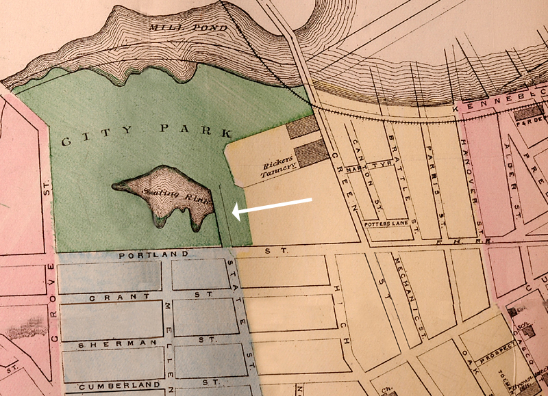
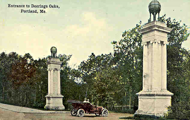
since
before 1874. Here's an 1884 map,
and a postcard from 1910.
Doesn't "reducing" the arterial (State St.) remove the Gateway that
supporters supposedly want to keep?
Facilitate access to designated
destinations by appropriate signage.
How about a street Sign: " Welcome to Portland,
and Deering Oaks!" (maybe not....).
Again, no Gateway, no "facilitation".
Address the I-295 corridor and
interchanges, future volumes, and safety issues in a manner consistent
with the Bayside Master Plan.
A hot topic with the Committee, until State
Traffic Engineer Steve Landry, backed up by the Federal Highway
Administration, told them very forcefully that the Master Plan "would
not be allowed in any way to change the operation of I-295".
That's a whole different
set of federal regulations and boards, and the state was
not going there!
Committee members looked a little askance at this forthrightness, gulped, and stumbled on.
Address capacity issues along
arterials.
Read: "Shut off State and High St. : Who
needs access to the Casco Bay Bridge anyway? "
The one problem with this last is that it re-opens the "gateway"
situation concerning the Oaks.
Don't want that.
Back to: Study Preface
Next to: Page x - Deering Oaks and
State Street