Deering Oaks,
Chapter 9 of the Peninsula Study
The Desired Results : Another Myth
This will be
a page-by-page analysis,
quoting from the Peninsula Traffic study.
The original document wording will be in
italic,
with
explanations under
each section in blue .
There will be some
repetition from page to page, as in the original document.
Chapter 9
Deering Oaks
The 1994 Deering Oaks Master
Plan identifies many actions to improve and preserve the park, including
one recommendation to “knit” together the areas of the park that are
separated by State Street and High Street in order to make the area
safer and more accessible for pedestrians. The City of Portland
undertook a study of High and State Streets in the vicinity of the
Deering Oaks with Wilbur Smith Associates in 1999 with the goal of
identifying alternatives to reduce the impact of these streets on the
Park. The outcome of the study included several alternatives, but the
City realized that to properly assess their feasibility, the analysis
needed to be viewed in the larger context of the Peninsula which was one
of the reasons this study was undertaken. This analysis included the
evaluation of several alternative strategies to improve the Deering Oaks
environment in the area along State Street between Forest Avenue and
Park Avenue. Specifically, the evaluation looked at the feasibility of
realigning State Street between Forest Avenue and Park Avenue in order
to enhance and improve Deering Oaks and its surroundings.
State and High Streets – This
included the evaluation of converting both State and High Streets from
their current one-way flow to two-way flow. Two scenarios were reviewed
including:
Full two-way conversion of both State and High Streets between Park
Avenue and York Street.
Partial two-way conversion,
which comprises two-way flow on both State and High Streets with the
exception of the segment between Danforth Street and York Street where
the current one-way flow pattern would remain.
Deering Oaks Area – The evaluation looked at the feasibility of
realigning State Street between Forest Avenue and Park Avenue in order
to enhance and improve Deering Oaks and its surroundings.
Except that increasing accidents, traffic congestion, air pollution,
decreasing pedestrian access, and eliminating parking does not really
enhance the area.
Page 9-1 :
Evaluation Criteria
Early in the study process a set of alternative evaluation criteria was
established to help
guide the development of alternatives as of the follows:
Ø
Reunite portions of the park now divided by a high-speed traffic
corridor.
Ø
Retain traffic mobility.
Ø
Reduce neighborhood impact.
Ø
Reduce speed and improve safety along the park roads.
Ø
Retain/enhance parking lot access.
Ø
Minimize tree impacts.
Ø
Minimize “Rose Circle” impacts.
Ø
Minimize statuary impacts.
Ø
Retain park “Gateway” to the City for vehicles.
Ø
Re-establish/enhance the historic park entrance and historic park
character.
Explanation:
Reunite portions of the park now divided by a high-speed traffic
corridor.
The contention was that people were having problems crossing 6-lane Park
Avenue to get
to the park, and also having problems crossing the State
St. cut-through to get to the Rose
Garden and back from the Duck Pond.
No mention has ever been made of just using the crossing signals at the
corners of State and Park.
What is also not mentioned is that Plan S-2, the desired plan,
will make Park Avenue 8 lanes
wide, somehow "improving access" over the current 6 lane width.
The “high speed” mentioned is 25 MPH.
Retain traffic mobility
Keep vehicle access to the streets and neighborhood intact. In light of the other stated goals of the proponents, this is facetious. More later.
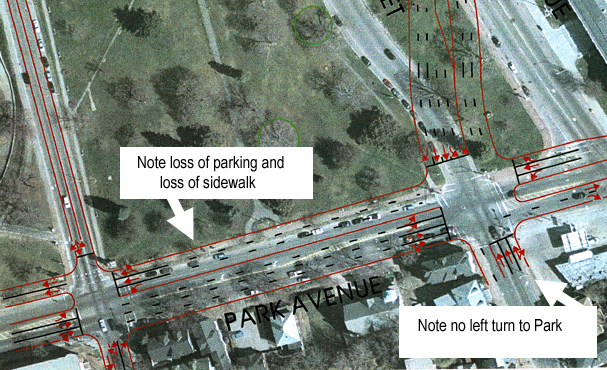
Reduce neighborhood impact.
Reduce the affect of vehicle traffic on the Parkside neighborhood.
The “Major features” of which are (from page 9-4):
-
Existing State Street segment between Forest Avenue and Park
Avenue closed to through traffic.
-
Creation of a new road combining Forest Avenue and High
Street between Park
-
Avenue and Kennebec Street
-
Creation of a Deering Oaks entrance at the Park Avenue and
State Street
intersection. -
Restricting movements at the Park Avenue/Forest Avenue
intersection
-
Converting State Street and High Street to Two-Way flow
between Park Avenue
and York Street -
Prohibiting left-turn movements on westbound Park Avenue at
High Street
-
Prohibiting left-turn movements on northbound High Street at
Park Avenue
-
High Street is widened to five lanes north of Park Avenue
Reference the last 3 items:
If you are going West on Park, you can’t turn up
High street. You have to go up State to
the Bridge or any other place at
the top of the Peninsula. If you are from out of town and don’t
know
this in advance, you are lost!
You also can’t turn left on Park off High, so if you are coming
down High and want to get to
The Expo, let’s say, you will have to take
some unknown route there. Maybe out on Forest,
left on Bedford, left on
Brighton, right on Park; about 2.5 miles versus the ¾ mile it would be
directly. For a look at
this turning situation , go
here.
Reduce speed and improve safety along the park roads
This is vague: The speed limit in the park is 15 MPH. The
speed limit around the park is
30 MPH. Assuming that 15 MPH is
OK, what is left is to slow the traffic on Park, Forest
and Deering St.
This would slow, congest, and tie up traffic.
Retain/enhance parking lot access.
The small parking lot in the park would be improved. “Enhance” means
increasing parking by
making both sides of the street parkable once the
street was shut off from Forest Ave.
Minimize tree impacts.
Being “Friends of the Oaks”
one can assume that they want to protect the trees, in their entirety.
Not the case. A minimum 40 trees would have to be cut down. See below.

This picture shows in pink the area along
Park Ave. where trees would have to be cut down to comply with
state and federal safety and construction requirements.
This assumes the extra 2 lanes added, a
parking lane, and a sidewalk with a berm by the road, to comply
with state roadway engineering standards.
31 trees
would be cut, by count.
If 10 feet is added to this width to comply with state and
federal design and safety requirements 85 trees come down.
Note that this number does not include the
High St. Forest Ave. reconfiguration which would require 10-14 more
trees to be cut. See below.
For a larger view of
this, see
here.
This the
Plan S-2 redesign for the Forest and High Street
combination.
There would be about 10-14 more trees cut for
this project, but one might assume that there would be more
planted in the space now used by road, , so in just 30-40 years, we
would have mature trees again.
For a larger view of this see
here.
Notice at the bottom the increase in lanes
on park, with no design for the sidewalk, which is eliminated
here.
As above, assuming a 4 foot berm as exists today,
and a 4 foot sidewalk, 85 trees will be coming down.
Minimize “Rose Circle” impacts.
Double-speak for “eliminate
the cut-through”. People could just wander across the
street/parking lot
instead of using the crossing lights.
Minimize statuary impacts.
Implied concern for the granite columns at
the State St. park entrance. Erected in
1904, they make a nice “gateway”
to the park. Again, not the case: see below.
Retain park “Gateway” to the City for vehicles
Again, implied concern for keeping the park
area as a “gateway” for people entering
from the West and I-295. Once
more, not the case : see below.
Re-establish/enhance the historic park entrance and historic park
character.
The
“historic” park entrance was the one on Deering Avenue. The “historic
park character” is
rather vague. Historically, up to 1927, the park was
surrounded by a candle maker, a
slaughterhouse, rendering plant, and a
gas works, among other fetid businesses that took 4 years
to clean up.
Probably not what they have in
mind, but who knows?
Page 9-2 : Deering Oaks Circulation Alternatives Evaluative Matrix
This was a matrix showing the
top 5 plans. Plan S-2 is the plan of choice, so I will discuss that plan
only.
|
Reunite portions
of the park now divided by high-speed traffic corridors. |
|
|
Retain traffic mobility. |
|
|
|
Pedestrian impacts at Forest and Park.
|
|
|
|
|
|
|
|
|
|
|
|
|
|
|
|
|
|
|
|
Retention/enhancement of the
historic park entrance and Park character |
|
Reunite portions of the park now divided…..
One of
the first lies- it was never united in the first place. See
Myth.
“High speed” is not
25 –30 MPH
Retain Traffic Mobility
The BIG lie:
Mobility decreases to a “D”
or “F” level, depending on
where you are on the road. This decrease for a federally and state funded project is a violation of federal and state law.
Project supporters have stated that congestion is their aim, because
that will drive
people away from the area. Redesign of all the intersections up and over
the peninsula will change the travel time from 2-3 minutes to 15-20
minutes.
With this decrease in mobility comes vastly increased
amounts of pollution, which violates the Clean Air Act, federal NEPA
requirements, and Maine DEP requirements.
Reference “May be
improved with traffic diversion to I-295 connector” , This is a flat-out
lie: supporters redacted
from their original report the design engineers findings that
they do not expect the public to use the
connector.
Reduce neighborhood impact
Another lie : The
contention is that pedestrians have a hard time accessing the park from
the peninsula because it is hard to cross the 6 lanes of road
between the park and peninsula (4 travel lanes, 2 parking lanes)
Their solution is to make the road 8 lanes wide, with a center
divider. Also, Forest
at Park would have to be widened 2 lanes , so crossing there
would be twice as wide as now.
I realize
this makes no sense.
This widening can be seen in the S-2 plan photo
above.
Speed and Safety along Park roads
This must concern
itself with the cut-through. The “high speeds” which do not exist,
will not on the side roads, because again, congestion is the
supporters aim. Traffic will be standing still.
Retention/enhancement of parking lot access
There would be more parking, as now both sides of the cut-through could be used. Overnight parking would not be allowed, except during snow emergencies. Notice again on the Plan S-2 photo above that there is NO parking anymore on the North side of Park Ave.
Tree Impacts
“Minor” : Another lie,
a big one: To conform with accepted roadway engineering standards when
widening to 8-lanes, a minimum of 31 trees, by count, would have to be
cut down along Park Ave. That’s a major impact, I’m sorry.
Add in the 10 for the High/Forest combination, and you are looking at a
minimum of 40 trees to be eliminated. If just 10 feet is added to this
basic width for clearance over the sidewalks, etc, 85 trees come down.
Rose Circle Impacts
The Rose Circle would have more visitors.
Maybe. Nothing prevents people from visiting the circle now.
The “difficulty” supporters have in getting to the Rose Garden
would be eliminated by crossing at the lights, but this seems to be too
much trouble.
Statuary Impacts
None- there is just one statue in the park,
by the Rose Garden. The granite columns would have to be moved / removed
to allow Park Avenue widening though.
Retention
of a “Park
gateway” to the city for vehicles
“Somewhat diminished” : That’s an
understatement for sure. The plan would congest traffic all around the
perimeter of the park.
Coming in from the West on Forest Avenue, instead of just
swinging into State St, passing through the park and continuing up State
St., you would stop at Park Ave, make a right turn, and immediately have
to get into the left lane to make a left turn up State.
The engineering analysis contention was that this situation would back up traffic to under and beyond the I-295 bridge during rush hour.
Retention / enhancement of the historic park entrance and Park character
Uncertain result: The original
“historic park entrance” was on Deering Ave, but another was
formed about 1884 by people driving their horse carriages over a
drainage berm at the bottom of State St. It was just closer to town.
The “park character” at the time was a little nasty if the wind
was wrong because of all the smelly slaughter houses and rendering
plants next to the park, so I am pretty sure supporters don’t want that
situation again.
Page 9-3
Analyses and Findings
The traffic analyses utilized the ‘Synchro’ and ‘Sim-Traffic’ modeling
software. The results for the two tasks are summarized below.
Deering Oaks
Four alternatives have been evaluated and their summaries are presented
in this document as noted below. Figures 8.1 through 8.5 illustrate the
alternatives which are located in the Appendix.
But Plan S-2 is the required plan. I
will be explaining just that one section, as the others were not in
play.
Ø
Alternative “A” – Traffic Calming Improvements on State Street
Ø
Major Features:
Ø
Implementation of Traffic
Calming Strategies on State Street between Forest Avenue and Park
Avenue.
Ø
Installation of a Traffic Signal
at Park Entrance on State Street.
Ø
Allowing the through
movement from Marginal Way westbound to State Street. However, if this
movement is allowed, the left turn from Forest Avenue onto Marginal Way
will need to be prohibited since both movements cannot occur without
backing up traffic onto I-295 when a train passes.
Alternative “B2” – Realigned State Street
Ø
Major Features:
Ø Existing State Street segment between Forest Avenue and Park Avenue closed to through traffic.
Ø
Construction of a new southbound roadway adjacent to High Street
connecting to the Park Avenue/State Street intersection.
Ø
Creation of a Deering Oaks Entrance on Park Avenue opposite State
Street.
Ø
Access to Deering Oaks from
Forest Avenue restricted to southbound right only.
Alternative “S-1” – Major Boulevard Concept
Major features:
Ø
Existing State Street segment between Forest Avenue and Park Avenue
closed to through traffic.
Ø
Creation of a new road combining Forest Avenue and High Street
between Park Avenue and Kennebec Street.
Ø
Creation of a Deering Oaks entrance at the Park Avenue and State
Street intersection.
Ø
Restricting movements at the Park Avenue/Forest Avenue intersection
Ø State Street and High Street remain in their current one-way condition
Page 9-4
Alternative “S-2” – Major Boulevard Concept with
Two-Way State and High Streets
Major features:
Note the “boulevard” – this means that a center median is planned, and
that at least 33 feet of the park has to be eliminated for widening, to
conform to roadway engineering standards. This is not stated as such,
but is the case. Keeps it quiet.
Ø
Existing State
Street segment between Forest Avenue and Park Avenue closed to through
traffic.
The cut-through is
gone.
Ø
Creation of a new
road combining Forest Avenue and High Street between Park Avenue and
Kennebec Street.
Requires cutting 10 trees.
Ø
Creation of a
Deering Oaks entrance at the Park Avenue and State Street intersection.
Ø
Restricting
movements at the Park Avenue/Forest Avenue intersection
You could go right, or left only in one lane around the median planned,
then right onto Forest/High. See
here.
Ø
Converting State
Street and High Street to Two-Way flow between Park Avenue and York
Street
Which were made
one-way in 1972 because the
congestion, accidents, and
general conditions were getting so bad something had to be done. Now,
with 60% MORE traffic in the area, supporters want to go back to 1972.
Ø
Prohibiting
left-turn movements on westbound Park Avenue at High Street .
Ø
Prohibiting
left-turn movements on northbound High Street at Park Avenue
Ø
High Street is
widened to five lanes north of Park Avenue.
For these last three , see
here.
Alternative “S-3” – Major Boulevard Concept with
Two-Way State and High Streets and Deering Oaks Access via Somerset
Street Extension Location
This option is very similar to Alternative “S-2” with the
exception of relocating the primary access/egress drive for Deering Oaks
from Park Avenue opposite State Street to Forest Avenue opposite the
future Somerset Street Extension. There is some information that
suggests that there was once an entrance in this vicinity. In general
this Alternative changes traffic flow at two locations when compared to
Alternative “S-2”, the Park Avenue/State Street and Forest
Avenue/Somerset Street Extension intersections. At both locations,
acceptable traffic conditions will be provided. Any consideration of
this alternative would need to be assessed for conformance by the
Secretary of the Interior’s standards for alternation to historic
landscapes.
Major features:
Ø
Existing State
Street segment between Forest Avenue and Park Avenue closed to through
traffic.
Ø
Creation of a new
road combining Forest Avenue and High Street between Park Avenue and
Kennebec Street.
Ø
Creation of a
Deering Oaks entrance at the Forest Avenue/Somerset Street Extension
intersection.
Ø
Restricting
movements at the Park Avenue/Forest Avenue intersection.
Ø
Converting State
Street and High Street to Two-Way flow between Park Avenue and York
Street.
Ø
Prohibiting
left-turn movements on westbound Park Avenue at High Street
Ø
Prohibiting
left-turn movements on northbound High Street at Park Avenue
Ø
High Street is
widened to five lanes north of Park Avenue.
Page 9-5
Recommendation
The conversion of State and High Streets back to two-way flow as described in Alternative S-2 merits implementation, as it satisfies the Criteria established on Page 9-1. It should be noted that this alternative is a compromise, as these changes result in long-term operational deficiencies from a vehicular perspective. However, the recommendation stands, as it will result in a street system and a park more in keeping with the historic fabric of the City. Interesting statement: It does join the park halves, but almost stops traffic, increases congestion and accidents, requires the street to be 35 feet wider which makes access harder, causes 31 trees minimum to be cut down, and makes the “gateway” uninviting, all of which does not “reduce neighborhood impact.”
The changes resulting in “long term operational deficiencies” means that
traffic will be slow, screwed up, dangerous, and polluting for decades. Decreasing Level of
Service of the intersections to a D or F rating is not a good idea. It’s
actually illegal, if done by design like this plan is doing.
Reference the “historic fabric of the city”: It’s questionable that the
park and streets had cars jammed up all around them at any time in the
past, and if they were like that, why would you want to go back
to that deplorable situation?
State and High Streets
During the study
process and evaluation of traffic mobility on the Peninsula, there was
an interest by the Study Committee to evaluate the implication of
converting both State and High Streets from its current one-way
configuration to two-way flow.
In 1972 State
and High Streets were converted from two-way to one way for the
following reasons: 1) during winter months with snow, parking became
problematic and initiated discussion on prohibiting parking along both
streets; 2) traffic congestion was problematic at some intersections
under two-way flow; 3) increase overall roadway capacity; and 4) truck
deliveries was problematic.
There is now 60% more traffic on the road. So they want to make parking
more problematic, increase congestion, decrease capacity, and do who
knows what to trucks.
Four alternatives
were evaluated for State and High Street, which are summarized below.
Figures 5 through 8 illustrate the alternatives, which are located at
the end of this chapter.
Full Two-Way State and High Streets
Major Features:
Ø
Conversion of State
Street between Park Avenue and York Street to a two-way street.
Ø
Conversion of High
Street between Park Avenue and York Street to a two-way street.
Ø
Implementation of
Alternative B2.
Alternative Pros:
Ø Improved accessibility. For who? If the area is packed with cars, like the planners say they will be, how can local or through traffic be improved?
Alternative Cons:
Ø
Poor traffic
operations at several intersections.
To wit: "several" means ALL of them, from Park Avenue to
York street, making the current 2-3 minute trip to the bridge into a
15-20 minute one. This is how the “F” rating
occurs.
Ø
Loss of on-street
parking.
Yes, like 36% of
all the parking on the streets.
Ø
Geometric
constraints at the Congress Street/State Street intersection.
Translation: The intersection redesign is going to cause
problems on Congress, the main street on the peninsula.
Part Two-Way State and High Streets
Major Features:
Ø
Conversion of State
Street between Park Avenue and Danforth Street to a two-way street.
(Page 9-6)
Conversion of High Street between Park Avenue and Danforth Street
to a two-way street.
Implementation of
Alternative B2.
Alternative Pros:
Improved accessibility.
Alternative Cons:
Poor traffic operations at several intersections.
Loss of on-street parking.
Geometric
constraints.
Full Two-Way State and High Streets with Deering Oaks Alternative
S-2
The Golden Fleece for the supporters. Unfortunately, it’s the general
public getting fleeced in this case.
Major Features:
Ø
Conversion of State
Street between Park Avenue and York Street to a two-way street.
Ø
Conversion of High
Street between Park Avenue and York Street to a two-way street.
Ø As stated, going back to 1972 levels of accidents and congestion with 60% MORE traffic. will lead to increased accidents, pollution, and congestion.
Ø
Restricting
movements from Forest Avenue at Park Avenue to right turns.
This is very
subtle: it means that inbound you would not be able to turn left on to Portland
St. to go to Preble, to go downtown! If you had to go straight up the
hill, a massive traffic jam would occur, which is why the designers
think traffic will back up beyond I-295 , and even ON TO the I-295
on-ramp!
Ø
Restricting
movements from the Casco Bay Bridge at State Street to through only.
This
means that you would not be able to go across the bridge from South
Portland into the Old Port. One would
have to go up State, then right on Danforth, a much smaller
residential street.
Ø
Providing two WB
York Street approach lanes at State Street
…taking two lanes
of traffic to one up State.
This is dangerous.
Implementation of
Alternative S-2.
Alternative Pros:
Ø
Improved
accessibility.
Again : for who?
Increased congestion does not improve accessibility.
Alternative Cons:
Ø Poor traffic operations at several intersections on High Street. Yes: ALL of them, from York to Park. “D” and “F” ratings for Level of Service. This is an illegal design.
Ø
Loss of
on-street parking.
A
36% of all the parking on the streets.
Ø
Geometric
constraints at the Congress Street/State Street intersection.
Again: a screwed up intersection by re-design.
Full Two-Way State and High Streets with Deering Oaks Alternative
S-2 and Peak Period Four Lane High Street
Major Features:
Conversion of State Street between Park Avenue and York
Street to a two-way street.
Conversion of High Street between Park Avenue and York
Street to a two-way street.
See above
Restricting movements from Forest Avenue at Park Avenue to
right turns
See above
(Page 9-7)
Ø
Restricting
movements from the Casco Bay Bridge at State Street to through only.
Ø
Implementation of
Alternative S-2.
Ø
Prohibiting parking
on High Street between Park Avenue and York Street during peak periods
and providing two travel lanes in each direction
Which means you
are gonna be towed during rush hour if you forget! Just like a
snow emergency….
Ø
Prohibiting left
turns from High Street onto Congress Street
So, if you are
coming into town to Maine Medical, or shopping, you can get there any
more, unless you want to cut through the side streets.
Ø
Providing two
approach travel lanes on westbound York Street at High Street.
Ø
Providing two WB
York Street approach lanes at State Street
Alternative Pros:
Ø
Improved accessibility.
For who? Where? It’s still a “D” or “F” rating for the
intersection, which means less accessibility.
Alternative Cons:
Ø
Loss of on-street
parking.
Yes, lots of it: bye-bye!.
Ø
Geometric constraints at the Congress
Street/State Street intersection.
Messed
up, see above.
Traffic Operations
The following tables summarize the results of capacity
analyses conducted during the future 2025 PM peak hour condition for the
four alternatives noted, a No-Build option (no roadway changes), and for
existing volume conditions assuming Alternative S-2 is implemented.
Intersection operations were based upon procedures contained in the
2000 Highway Capacity Manual, Transportation Research Board. The
standard used to evaluate traffic operating conditions of the
transportation system is referred to as the Level of Service (LOS). This
is a qualitative assessment of the quantitative effect of factors such
as speed, volume of traffic, geometric features, traffic interruptions,
delays, and freedom to maneuver. Six levels of service are defined in
the Highway Capacity Manual. They are given letter designations ranging
from LOS A to LOS F, with LOS A representing the best operating
condition and LOS F the worst.
The general
standard for level of service is that “D” or better be obtained.
However, in an urban environment where constraints exist perhaps due to
buildings, parks or other urban features, acceptance of lower levels of
service may be appropriate.
Maybe so, but it’s ILLEGAL to DESIGN it into the project. It's a
violation of federal law. Horrid
circumstances may require a low LOS, but MAKING it that way is illegal. Notice the LOS below, in the first “do-nothing” column – all
better than the rest!
I mentioned to a Planning Dept. member that the estimated 2025
congestion levels are still better than any other, and that with Plan
S-2 we would have all that congestion NOW, instead of in 2025!
He said: That’s true.” , which means that we would have all that
congestion and pollution right now, instead of 13 years or so from now.
Table
8.1: State Street Intersections
|
PM Level of Service and Delay
INTERSECTION |
2025
NO-BUILD |
2025
FULL TWO-WAY |
2025
PART TWO-WAY |
2025
ALT. S-2 |
2025
ALT. S-3 |
|
State @ Park |
C(25) |
E(60) |
E(58) |
C(22) |
C(20) |
|
State @ Cumberland |
A(9) |
B(16) |
B(15) |
C(21) |
C(21) |
|
State @ Congress |
B(15) |
D*(48) |
D*(47) |
C(32) |
C(32) |
|
State @ Spring |
B(18) |
D*(49) |
D*(55) |
C(26) |
C(26) |
|
State @ Danforth |
B(14) |
C(24) |
C(27) |
C(33) |
C(33) |
|
State @ York |
F
(88) |
F
(189) |
F
(88) |
D(42) |
D(42) |
(Page 9-8)
Table 8.2: High Street
Intersections PM Level of Service and Delay
|
INTERSECTION
|
2025 NO-BUILD |
2025 FULL
TWO-WAY |
2025 PART
TWO-WAY |
2025 ALT. S-2 |
2025 ALT. S-3 |
||||||
|
High @ Park |
C(27) |
D(42) |
D(44) |
D*(36) |
D*(36) |
||||||
|
High @ |
B(12) |
C(21) C(20)
D(43) |
D(43) |
||||||||
|
High @ Congress |
E(79) |
F(103) |
F(104) |
C(26) |
C(26) |
||||||
|
High @ Spring |
C(27) |
C*(35) |
C*(30) |
C(29) |
C(29) |
||||||
|
High @ Danforth |
B(15) |
B(11) |
D*(50) |
C(26) |
C(26) |
||||||
|
High @ York |
C(19) |
D*(41) |
C*(21) C*(24) |
C*(24) |
|||||||
X – level of service
(xx) – delay in seconds
* Some movements with LOS of E or F
As noted in the previous tables several locations are anticipated to
experience greater congestion and some intersection levels of service
will deteriorate to poor levels of service (LOS E or F).
As noted before, the “several locations” are
ALL of them, and “some intersections” are again, ALL of them.
This is rampant prevarication.
On-Street
Parking Impacts
A qualitative evaluation of parking impacts associated with the
conversion of State and High Streets to two-way circulation was
conducted. The evaluation was based upon current parking restrictions,
projected vehicle queues, turn lane needs at intersections under future
traffic volumes, and implementation of Alternative S-2. It should be
noted that reduced parking impacts are likely under a short-term traffic
volume condition where requirement for turn lanes are lessened. The
following summarizes the results on each street between Park Avenue and
York Street.
High Street
Ø
High
Street between Park Avenue and Cumberland Avenue
– Under the Alternative S-2 concept, High Street will need to provide
five lanes of traffic (three northbound approach lanes at Park Avenue
and two departing lanes) to attain the best possible level of service at
the Park Street/High Street intersection. Accordingly, all on-street
parking (three spaces eliminated on the east side of High Street) will
be prohibited between Park Avenue and Grant Street. North of Cumberland
Avenue, five spaces (from either side) will be eliminated due to the
need for a left-turn lane to accommodate 7 - 4 PM peak hour left-turning
vehicles onto eastbound Cumberland Avenue.
[8 lost Parking Spaces]
Ø
High
Street between Cumberland Avenue and Congress Street
– High Street north of Congress
Street is 33 feet wide. Three-lanes on High Street approaching Congress
Street will be necessary to accommodate the left-turning volume (103 PM
peak hour vehicles) onto eastbound Congress Street. Two approach lanes
and one departing lane. Parking (seven spaces) will need to be
eliminated on the west side of High Street near Congress Street. It
should be noted that some widening of the curb line may be necessary to
accommodate maneuvers for large vehicles.
[7 Lost Parking
Spaces]
Ø
High
Street between Congress Street and Spring Street
– High Street is 47 feet wide
north of Spring Street. Three-lanes on High Street approaching Spring
Street will be necessary to accommodate the left-turning volume (36 PM
peak hour vehicles) onto eastbound Spring Street. Two approach lanes and
one departing lane. Parking (six spaces) will need to be eliminated on
the east side of High Street near Spring Street.
[6 Lost Spaces]
Page 9-9
Ø
High Street between
Spring Street and Danforth Street
– High Street is approximately 40 feet wide near Danforth Street.
Three-lanes on High Street approaching Danforth Street will be necessary
to accommodate the left-turning volume (64 PM peak hour vehicles) onto
eastbound Spring Street. Two approach lanes and one departing lane.
Parking (five spaces) will need to be eliminated on the east or west
side of High Street near Danforth Street. Danforth Street is
approximately 39 feet wide and 10 parking spaces may be lost on the
south side of Danforth Street on both east and west of High Street due
to the provision left-turn lanes. The Danforth parking reduction is not
included [5
Lost Spaces]
Ø
High Street between
Danforth Street and York Street
– High Street is approximately 40 feet wide. With the need to
provide four travel lanes near York Street, a loss of 10 spaces is
likely. The provision of four lanes is necessary to accommodate the two
lanes turning from York Street northerly up the hill toward Danforth
Street and the need to provide two approach lanes on southbound High
Street at York Street. Six spaces would be lost from the east side and
four spaces from the west side.
[10 Lost Spaces]
Total Lost Parking Spaces on High Street = 36+/- Parking Spaces
Total Parking Spaces
Provided on High Street = 113 Parking Spaces
Percent Reduction in On-Street Parking = 32% 32% loss!!
State Street
Ø
State Street between
Park Avenue and Cumberland Avenue
– State Street between Park Avenue and Grant Street is 40 feet wide
and State Street will need to provide three lanes of traffic (two
northbound approach lanes at Park Avenue and one departing lane) to
attain the best possible level of service at the Park Street/State
Street intersection. Accordingly, all on-street parking (8 spaces
eliminated) on the east side of State Street will be prohibited between
Park Avenue and Grant Street.
[8 lost Parking
Spaces]
Ø
State Street between
Cumberland Avenue and Congress Street
– If a left-turn
lane is not provided at Cumberland Avenue in the northbound direction no
parking loss. [0 lost Parking Spaces]
IF
a left turn lane is not provided.
Ø
State Street between
Congress Street and Spring Street
– Due to the need for intersection improvements at Congress Street
(provision of two northbound approach lanes at the Congress Street/State
Street intersection) three parking spaces will be eliminated. [3 Lost
Spaces]
Ø
State Street between
Spring Street and Danforth Street
– State Street is approximately 42 feet wide. It is assumed that
left-turn lanes on both northbound and southbound State Street are
required resulting in a loss of three parking spaces on either side.
Danforth Street west of State Street is approximately 40 feet wide.
Assuming prohibiting parking on one side to allow for a left-turn lane,
8 parking spaces will be lost. The Danforth reduction is not included
[3 Lost Spaces]
Ø
State Street between
Danforth Street and York Street – [0 Lost Spaces]
Total Lost Parking Spaces on State Street =
14 +/- Parking
Spaces
Total Parking Spaces Provided on State Street = 136 Parking
Spaces
Percent Reduction in On-Street Parking = 10%
10% loss
So, there will be a 42% loss of parking on
two streets in a neighborhood packed with apartment houses and homes.
Sounds like a bad idea……
Page 9-10
Impacts at Congress
Square and Longfellow Square
Longfellow Square
A conceptual design was prepared to quantify the impacts of
converting State Street to two-way flow. Based upon the preliminary
evaluation, conversion of State Street to two-way flow is feasible. The
following should be noted:
Ø
The right-turn
channelization island from Congress Street to southbound State Street is
being eliminated.
Ø
Some parking would
need to be prohibited on State Street near Pine Street.
Ø
The corner near the
Longfellow Monument would need to be modified, but impacts to the
monument are not anticipated.
Ø On State Street north of Congress Street some parking impacts are expected, but no loss is anticipated, only a shifting from the east curb to the west curb.
Congress Square
A conceptual design was prepared to quantify the impacts of
converting High Street to two-way flow. Based upon the preliminary
evaluation, conversion of High Street to two-way flow is feasible. The
following should be noted.
Ø
Minor widening on
High Street north of Congress Street will be required. It may be
possible to avoid minor widening if turn restrictions are implemented.
Ø
Corner curbing will
need to be enlarged.
Ø Some existing parking spaces will need to be eliminated on High Street.
Page 9-11
Deering Oaks
Recommendations
The primary objectives of the analyses in this chapter were to determine the best approaches to reconnect Deering Oaks and recapture State and High Streets as integrated elements of the City of Portland. The analyses of the various options to realign State and High around Deering Oaks and to implement two-way operation show that the aesthetic and community gains of these actions would result in degraded traffic operations at several City intersections. State and High are arterials, and as such are as “integrated” as much as they are going to get. They are the lifelines for the city’s traffic. Without arterials the city becomes gridlocked. The supporters somehow think that the “aesthetic and community gains” are worth the congestion and pollution this plan would create. The question is : How are increased pollution, accidents, traffic congestion “aesthetic”?
Given the potential cost in dollars, loss of parking,
motorist delay, and congestion in the City, a stepped approach to
achieving the desired goals is recommended. As has been discussed in
other areas of this report, the I-295 connector to Commercial
Street/Casco Bay Bridge is currently under construction. When that
project is complete, a viable alternative to the State/High one-way pair
will be in place. As indicated in Table 4 of Chapter 4, there is a pool
of 924 AM and 969 PM peak hour trips that could
potentially
divert to the new connector. This could significantly reduce traffic
flow along the State/High one-way pair. Therefore, it would be advisable
to allow traffic patterns to stabilize once this new route becomes
available to see if there is significant volume reduction. An interim
step if volumes have not dropped after the traffic patterns stabilize
would be to consider disrupting the progression along State and High to
discourage their use by through traffic, thereby maximizing diversion to
the I-295 connector.
What they mean here by "disruption" is that there was a plan to CLOSE OFF
State street to through traffic, to force people to use the new
connector. The “potential” diversion of traffic was never expected by
the supporters. This negative expectation was actually reported in the
original report , but then removed by the supporters as being
contrary to their effort, which it surely was. That redaction is illegal under Maine law, as being
unrepresentative of the truth.
The major objective in undertaking the analysis of traffic
flow through the Deering Oaks area was to determine if there was a
feasible alternative to improve conditions in the Park. This was a
difficult assignment given the heavy traffic volumes and desired travel
patterns in the area and therefore resulted in evaluation of a
considerable number of alternatives,
many of which
have not
been discussed here due to inherent flaws. The majority of the
alternatives failed after evaluation except for alternatives S-2 and
S-3. These alternatives are feasible but compromise mobility to a
certain extent in favor of other policy objectives which raises a number
of policy issues which need to be considered by the City in determining
a course of action:
What they are saying here is
that the other plans put forth had MORE problems than Plans S-2
and S-3! Considering that
S-2 and S-3 are sheer disasters, those problems must have been
astounding.
The “certain extent “ of mobility compromisation equates to gridlock.
This is an unbelievably
massive understatement.
The “policy issues” which need to be considered are those of violations of state and federal law, the Clean Air Act, NEPA, and a host of other flat-out illegalities.
Ø What is level of delay to motorists is appropriate in this area? Traditionally, the City has required a level of service no less that a “D” at signalized intersections. Welcome to “F”: like it.
Ø
Is the City willing
to implement these improvements if they will reduce the level of
service?
To keep their
friends happy, they sure will if they can get away with it.
Ø
Would the project be
eligible for PACTS and or the MAINE DOT cost sharing if the level of
service is not enhanced?
NO-
that’s why the feds and state told the city it was on its own.
Ø
Would the MAINE DOT
allow alternative S-2 or S-3 even if they were not funding the project?
Their approval would be required since State and High Streets are
designated as State Route 77.
NO.
Route 77 is part of the National Highway System, and as such, federal
law applies. If the City took Rte. 77 out of the NHS (which it can do),
77 would no longer be eligible for federal funding for rehab, or
whatever. To wit: the City would have to pick up the entire tab for the
Casco Bay Bridge, about $40,000,000.
These policy issues are critical to advancing traffic
mobility in the City. Other objectives like maintaining its natural
infrastructure and promoting neighborhood quality of life and stability.
The City should enter into high level talks with MDOT to explore these
issues.
For any of the improvement strategies, it is recommended
that landscaping be a key consideration in the design process. Traffic
islands should be landscaped and roadway should have a high level of
streetscape incorporated.
Interesting statement: They just said that mobility was tanking because of the project, but now the policy issues (willful negation of, or just ignoring of, the law) have to be resolved to keep mobility going. Maybe this is a hint that certain things should not be pursued? Like Plan S-2?
The City entering into “high level talks with MDOT” means that the city has to tell MDOT to buzz off, and pay for it anyway, even though the project is illegal. Being a fly on the wall would be interesting for those meetings!
“High level of streetscape” means :“plant more trees and bushes!”