Peninsula Traffic Study:
Deering Oaks and State St., Page X
From the Peninsula Traffic Study:
Deering Oaks and State Street, Page x
My comments in blue: the subtext.
Deering Oaks is the keystone in a city-wide network of parks, public spaces, and trails. The Oaks help beautify the City, provide important recreational areas for residents and tourists, and serve as a counterpoise to adjacent commercial and densely-populated residential districts.
In recent decades, Deering Oaks has
been affected by significant roadway projects such as the construction
of I-295 as well as the extensions of State and High Streets. As a
result, the historic rose garden was cut off from the park, and large
volumes of traffic routes by the duck pond. This
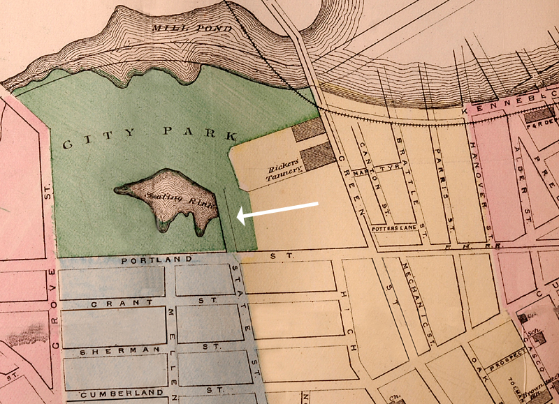
is a flat-out lie. State was extended into
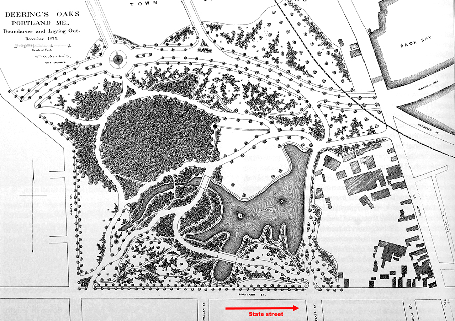
the park in the 1870s, as seen here, much before the Rose Garden was installed in
1933. The original master plan map for the Oaks from 1879 is
here. I see a lot
of buildings to the right, but not a lot of Rose Garden. It was
specifically
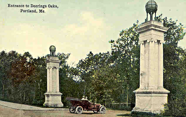
widened for auto traffic in 1907 : (postcard
from 1910) .
See "The Rose Garden Myth" in the links at left for more on this.
The Traffic Plan recommends that the following changes be implemented to restore the Park as well as accommodate long-term traffic patterns in the Peninsula:
The State and High Street extensions are to be combined into a single boulevard through the Park. Requires cutting 10-15 trees minimum. This, in addition to the 2-lane widening of Park Avenue that is proposed, would be a disaster for the park. A minimum of 31 trees would have to be cut for just that widening to happen. If you want a sidewalk along Park Ave., by the park, we are looking at 85 trees to be cut down.
The Rose Garden is to be reconnected to the main portion of the Park.It was never "disconnected" - it was specifically built for that space in 1933.
The original Park entrance on Park Avenue is to be restored to provide controlled, dead-end pedestrian and vehicular access and parking. "Restored" is a misnomer. The original entrance was on Deering Avenue, as seen in the 1879 master plan.
The restoration of two-way traffic on State and High Streets between Park Avenue and York Street. This will increase accidents, congestion, impede winter operations and truck operations, as it was doing in 1972 when the roads were made one-way because of all those problems. Now with 60% more traffic on the street, they want to go back 40 years.
Creation of a new road combining Forest Avenue and High Street betweenPark Avenue and Kennebec Street.
Is it Forest and High Street? Or State and High? Or State, High, and Forest?
Creation of a Deering Oaks Entrance at the Forest Avenue/Somerset Street Extension intersection.
Prohibiting left-turn movements on westbound Park Avenue at High Street.This means that you will not be allowed to turn left up High outbound on Park. If they
don't want you on State, where do you turn to go out to the Casco Bay Bridge?
How do you get there? One contention is that drivers would have to get on I-295,
drive south to the Fore River Connector, then take Commercial St. to the ramp for the bridge, a trip of about 4 miles.
Prohibiting left-turn movements on northbound High Street at Park Avenue.So if you are coming down the hill on High, you can't turn left to get to the Park,
or out to Congress St.... So, if you wanted to go to McDonalds on St. John, let's
say, you would have to get on I-295, go south to the Congress St. exit, go back
North on Congress then turn left on St. John St.
Or, turn left on Cumberland, Sherman, or Grant, streets, travel over to State,
Deering, or Mellen, make a right on one of those, go to the bottom, and left on Park .
Considering that the Parkside Committee is trying to reduce traffic through their
neighborhood, this makes no sense.
Restricting movements at the Park Avenue/Forest Avenue intersection.Ditto for High and State : You are headed out of town buddy- no left turns for you!
It is important to realize that these
changes to State and High Streets result in the loss of some on-street
parking as well as operational efficiency at certain locations. In
addition, these changes will have the potential for geometric
alterations at major intersections along State and High Streets.
However, the potential benefits, in terms of vehicular speed and
accessibility improvements offset these losses.
There is a 46% loss of parking in this
highly populated area. Sounds like a plan, doesn't it?
The 'potential for geometric alterations at major
intersections" is 100% , up and over the Peninsula, to the bridge.
The
"loss of operational efficiency" will turn the current 2-3 minute
trip into a 10-15 minute one. This redesign degrades the intersections
to a "D","E", or "F" grade, which is illegal, if designed that way.
"Improvements" here is used in a "negative"
way here which creates a "benefit": decreasing vehicle speeds and accessibility causes
congestion. Congestion is what the supporters want, to drive people away
from "their" streets and park.
Vehicle speeds BTW, are 15-25 MPH.
It should also be noted that the
changes to State and High Street assume that the I-295 Connector Road is
operational. This roadway, to be completed within a few years, will
provide direct access from I-295 to the western waterfront as well as
the Casco Bay Bridge. The expectation is for reductions in traffic
volumes along State and High Streets as a result.
Traffic would
decrease if drivers actually used
the road. The more direct access is off I-295 and
up and over on State St.
What the authors of this study don't
say is that their original report stated that they didn't
think drivers would use the connector.
That finding got taken out, because it looked too
bad. Said redaction is illegal.
Today, drivers from the North and West don't use it that much. It's not that direct a route. You
can get to Chicago from New York via Los Angeles, but why bother?
Next to: Chapter 9, Deering Oaks, in it's entirety
Back to top