About This Site
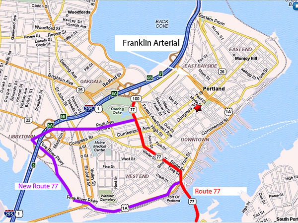
Franklin Arterial Re-design
 F
F
ranklin
Arterial is a major road /arterial in Portland. Route 1A is
on part of it, from the South running across the Veterans Bridge,
then along the waterfront on Commercial St. to the Casco Bay Bridge,
continuing under that to the Old Port and commercial seaport facilities.

Leaving the downtown proper, it makes a sharp left
onto Franklin, up and over the peninsula, meeting
I-295 at Bayside . It's the major truck route for the city, vital to the
commercial success of Portland.
And the City wants to shut it down....rather,
constrict the section that goes up and over the peninsula to I-295, this
in an effort to make Portland "more walkable".
(click on map for larger view)
The purpose of this project is nebulous. Originally the Munjoy Hill Association was contending that Franklin was a blight on the city, cutting it in half, and that people walking down Munjoy Hill had to make a herculean effort to cross 2 lanes of traffic, then walk 125 feet, then cross another 2 lanes of traffic. Nothing has ever been said about the next intersection a block down, and the ones after that...Portland IS a city....but these two roads are supposedly like the Berlin Wall to Munjoy residents .
Here's "blight", last October 2014: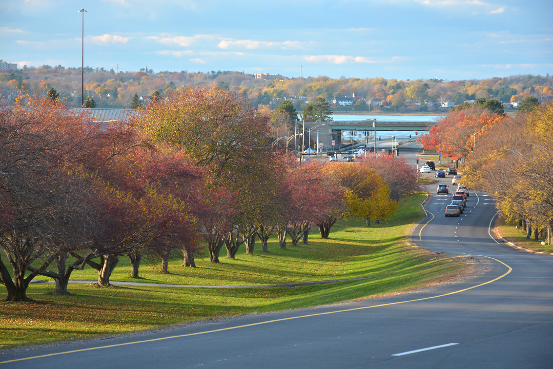
This is all due to be eliminated and built upon , as
it's called
an "ugly gateway" to the city; "waste land" by the
project supporters. The trees have finally matured
into beautiful coverage after 30 years of growing. I think it's
pretty.
______________________________________
April 5, 2015 Update: The Franklin Committee met last Wednesday for the last time. General consensus is that the narrowing and addition of cross street entrances to Franklin is good as it will slow traffic even more. Also, they added a roundabout at the intersection of Franklin and Commercial, saying that it's dangerous for pedestrians.
Phase I of this $26,600,000 project is to be the intersection "improvements" at Franklin and Commercial. Phase II will be Franklin / Marginal way, with Phase III being the cross-road cut-throughs and crosswalk installations along the downslopes.
The Critical Rate Factor is a general indicator of the safety of a road or intersection, generated by the number of incidents. From FHWA: " It represents the expected collision rate of locations with similar characteristics .... The critical rate is calculated based on the system-wide average collision rates for intersection or road sections of a similar characteristic. If the actual collision rate is greater than the critical rate, the deviation is probably not due to chance, but to the unfavorable characteristics of the intersection or road section...."
TThe CRF for Franklin /Commercial is .37 with 6 accidents in 3 years, just one involving a pedestrian.
The CRF for Franklin / Marginal way is 1.63 with 65 accidents and one bicyclist.
My question is that if this is really a SAFETY project, why is Franklin /Commercial being done first? One might assume that the intersection with 10 TIMES the number of accidents as the next in line would be corrected first to enhance the "public safety". But then this is Portland.
I have the feeling that the roundabout, contiguous sidewalk widening, and landscaping is being pushed to cutify the Old Port in the hope they can make it look prettier before the money runs out......To hell with Bayside and the real problem.
This is all going to the City Council next month or so, so we will see what happens. One can only hope that MDOT will make the City take care of the real problem first, if not nip the whole thing in the bud.
There are currently two websites on this project, one by the Franklin Reclamation Authority (sounds serious) :
http://franklinstreet.us/
and the City of Portland Franklins Street Committee
page:
http://www.portlandmaine.gov/660/Franklin-Street-Committee-Phase-
And even a Facebook page! : http//www.facebook.com/FranklinStPhase2 This is kind of funny. The only comments are on the Oct. 7, 2014 question about "What do you think!" of which the nicest comment was "It sux". Most of the links don't work either.
There is LOTS of details on what they want to do- and three "finalists" have been chosen, as of this writing (4/15).
THIS page gets me going: http://franklinstreet.us/the-franklin-reclamation-authority-fra/whats-wrong-with-franklin The author tries to smear it even more with bad photos and slanted verbiage:
"Franklin
Street Arterial is based on a suburban model of auto-oriented design
which does not accommodate other modes of transportation."....I've
biked down this many a time, and the picture they show has somebody
walking across it.
As for being a "suburban model" I think most cities in the First
world outside of little villages in the Alps have two-lane roads. You
could land a small plane on this , but I don't think the writer
has that in mind.
"/em>It
is a barrier that is not a “Place,” but somewhere to drive through.--"
Place" being somewhere that people should be hanging out at or on? The
City has been trying to get people OFF this median down at Marginal way,
because they think it's dangerous. Also, as a "gateway" it's probably
the best looking one in the whole town. What it's a "barrier" to is
uncertain, because the project supporters lament all the people walking
across the road as being dangerous, even though all the accidents are
occurring at the intersections!
It is unsafe for pedestrians, bicyclists,
and motorists......Not if the
peds and bikers obey the traffic laws. Cross at the light maybe?
Literally half of the ped/bike /vehicle accidents are the fault of the
ped or biker, not the driver. More on that later.
"It pollutes the air". But not anywhere near as much as this project will ! You slow traffic down, constrict the roads, have cars idling in place, and pollution skyrockets. Hello Honolulu.
"It severs historic neighborhoods, cross streets, and walking routes" That's true...of any street in the city. The "walking routes" I don't understand. The big complaint is that there IS an allegedly dangerous walking route across Franklin created by people who are cutting through a guys yard and knocking down a chain link fence, which really irritates HIM. If people were walking where they were supposed to, on the sidewalks at the lights, then they supposedly wouldn't have this danger problem (which, BTW, exists only AT the lights according to the accident records. )
"It separates downtown from its neighborhoods".....Only if you look at it that way. All one has to do is cross the street. Some might see it as a nice buffer. Biddeford Pool is "separated" from Camp Ellis and Old Orchard Beach by the Saco River and that's the way they like it. Ditto Pine Point separated from Scarborough by the Nonesuch. The latter towns see the open space as an asset.
"It is out of scale with the surrounding city".....Not for a two-lane road it's not...the lanes are narrower than Congress, Forest, Stevens, Brighton, etc. ; AND it's a major access point TO the city.
And last, my favorite: "it is an underutilized area that detracts from urban density, limits the potential for mixed use development, and creates unusable open space......It "detracts from urban density" ! Like having buildings jammed together with no green space is a GOOD thing? I'd be curious to know what the writer thinks about Central Park or Boston Common : blight! This guy doesn't want to just pave the bare spots, he want to eliminate them completely! Look out Tommy's and Post Office Parks: blight!
" ...limits the potential for mixed use development" : Well, you can develop things all you want to but if people can't GET to those projects, guess what- they will go elsewhere.
"creates unusable open space." - WOW. How about an oil refinery or chemical plant on your "open space" - would that be good? How about something like Wall Street? Downtown Boston? Nah...probably gotta be a boutique or hipster coffee shop of some sort in there I suppose...and watch out, Payson Park!
Green space is a detriment to a city......What can you say.......